The area of Wyke Down is situated in the upper Allen Valley, part of Cranborne Chase in the north-east part of the county of Dorset. It contains three sites which Project Time will be focusing on; Monkton-up-Wimborne, Wyke Down itself and Fir Tree Field. This area, a classic example of chalk downlands in southern England, contains a rich array of sites and monuments, including the Dorset Cursus, and the group of earthen enclosures at Knowlton, including the evocative ‘Church Henge’, an earthen enclosure with the upstanding remains of a 12th century church in the centre. This project focuses on three of the sites in this area; the Grooved Ware and Beaker pits at Fir Tree Field, the two pit ‘henges’, buildings and associated pits at Wyke Down, and the unique pit circle and shaft complex at Monkton-up-Wimborne.
Monkton-up-Wimborne
First discovered by Martin Green in aerial photographs in 1996, and excavated in 1997, the Monkton-Up-Wimborne pit circle and shaft complex is located on a chalk ridge on the eastern side of the Upper Allen Valley, c1.5km to the east of Fir Tree Field, and just over 1km south-east-east from Wyke Down. It is made up of a ring of 14 pits in a circle, with a diameter of c.35m, and wide entrance gaps on the eastern and western side of the circle. This pit circle surrounded a central pit (F.1), 11m wide and 1.5m deep, with vertical sides and a notably even and smooth base, the result of the original excavators stopping at a band of natural solid chalk. The excavators suggested that the spoil created may have been used to create a bank running around the central pit (however, no trace of any upstanding bank has survived). The next evidence of activity after F1 was the digging of a small pit (F.23) in the northern side of F1, undercutting the edge. This pit contained four crouched inhumations, including an adult female and three children, and was carefully backfilled with packed chalk rubble.
After a short time, in which the base of F.1 accumulated some weathering sediments, a large shaft was dug in the eastern side of F.1, 4.5m wide at the top, and 7m deep. At least some of the spoil from the shaft was deposited in the base of F.1, creating a crescent ‘platform’ running around the western side of the shaft, with the southern extent deposited up against the side of F.1, forming a ramp, which would allow access into the central pit from ground level. At this point the outer circle of pits are thought to have been dug as well; a number of the pits contained blocks of chalk at their base, which could only have come from deep excavations into the bedrock. Finds from the outer pits were sparse, but did include a kite shaped arrowhead, a flake from a polished flint axe, small scraps of Peterborough Ware ceramics, and animal bone. After their excavation, the outer pits were left to weather and silt up naturally.
Once opened, the shaft began to fill in; within these deposits, a number of notable artefacts and collections of material were recorded. The remains of a partially articulated piglet, a carved chalk block, a pecked sandstone ‘ball’ and other animal bones were recovered from the base of the shaft. The lower fills of the shaft, made up of chalk rubble, contained further carved chalk objects, a red deer antler pick, and a pig skull, worked chalk object and larger flint pebble deposited together. The material recovered from the upper fills of the shaft, made up of rubble and silty deposits, included a whole cow skull and red deer antler deposited close to a group of human skull fragments, and a very fine leaf-shaped arrowhead close to another group of disarticulated human remains. As well as these distinctive depositions, the shaft also contained further animal bones, lithics and Peterborough ware ceramics. The material recovered from the shaft was interpreted as material deriving from activities being undertaken on the platform above; further lithics, ceramics and animal bone were recovered from within and on the platform, including animal bone scatters on the western edge of the platform, which may be the remains of in-situ activity on the platform.

Once the shaft was completely filled, the central pit as a whole began silting up. The lower silting layers contained lithics, including chisel arrowheads, and flakes of polished stone axe. Above this layer, a dark organic soil horizon formed, containing a contrasting lithic assemblage, containing small scrapers and barbed and tanged arrowheads, and small fragments of Beaker ceramics. Within this layer, in the centre of the pit, a single male flexed body was sealed beneath a small flint cairn, with their head pointing and feet orientated towards the eastern and western entrances of the pit circle respectively.
Dating the Monkton-up-Wimborne Pit circle and Shaft Complex
Existing dates for this site come from the base of F1, one individual from F23, one date from the shaft and a final date from the later inhumation. These indicate the earliest activity occurred during the second half of the 4th millennium BC, and runs through to the later inhumation in the early-mid 2nd millennium BC (what would be called the bronze age).
The focus for re-dating this site is two-fold. Firstly, new measurements from the shaft will offer a more detailed picture of when the shaft was initially dug, the temporal relationship between the shaft digging and the earlier F.1 pit and F.23 inhumation, how long the shaft took to fill up, and in turn, the temporal character of the activities on the platform, from which the shaft material came from. Secondly, although the presence of chalk blocks within the outer pit circle suggest they are broadly contemporary with the excavation of the shaft, there are currently no radiocarbon dates for these features. Therefore, new dates will allow the outer pit circle to be tied into the chronological sequence of this site.
Beyond the context of the site, a more detailed chronological understanding will chronological comparisons between the unique enclosure at Monkton-up-Wimborne and other unusual late 3rd millennium enclosures and pit circles, such as Flagstone (Dorset) and Dorchester-On-Thames (Oxfordshire), which also have evidence for changing mortuary practices during this period.
Further reading
Read this account, written by Martin Green, about the discovery and excavation of the pit circle and shaft complex at Monkton-up-Wimborne
French, C. et al. (2007) Prehistoric landscape development and human impact in the upper Allen Valley, Cranborne Chase, Dorset. Cambridge: MacDonald Institute for Archaeological Research. (pages 114-121)
Wyke Down
First excavated in 1983/4 and again in 1996, Wyke Down is located on a south facing portion of the upper Allen Valleys eastern slopes, 700m northeast of Fir Tree Field Shaft and just over 1km northwest-west of Monkton-up-Wimborne. Investigations at Wyke Down revealed two pit-defined ‘henges’ (Wyke Down 1, and Wyke Down 2), and a collection of pits and post holes to the south of Wyke Down 2 indicative of activity and potential structures.
Wyke Down 1
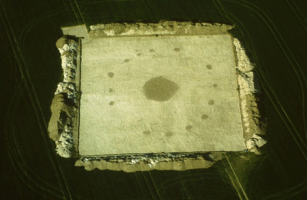
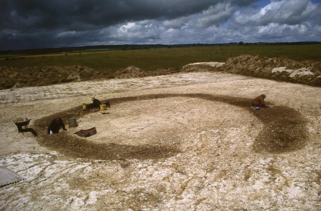
The first site at Wyke Down to be excavated was Wyke Down 1 ‘henge’, which was originally identified from aerial photographs, and interpreted as a ploughed-out round barrow. On stripping away the overlying ground surface, 26 pits cut into the chalk were uncovered in four distinct arcs, making up an enclosure 19.5m x 17m, with an entrance to the south, and a pit at the centre. Each pit ranged in depth from 1.05 and 2m, with the deepest pits found at the entrance and towards the back of the monument. It is possible that the spoil produced by the original excavation of the pits may have been used to create an external bank, as seen on other ‘henge’ monuments in Britain and Ireland, however, no remains of a bank was identified.
The evidence from the pits indicates two main phases of activity. In phase I, the pits were dug, before filling up, firstly with chalk rubble, and later with finer silts and humic lenses. These phase I pits had a range of artefacts within them, including a number of deposits into the very bottom of the pit. These included red deer antler tools (two picks, and two rakes made from the crown of the antler) deposited at the base of the pits close to the entrance, six carved chalk objects, four deposited in pits around the entrance, and a further two from the pit opposite the entrance, and bones from cow, pig, sheep/goat and red deer, again focusing around the entrance. The pits also contained lithics, and whilst they were more widespread than other materials in phase I, an arrowhead was found at the base of both pits flanking the entrance.
After a period of filling up, a second phase of activity began (phase II); new, ‘re-cut’ pits were dug into the center of the silted up phase I pits. The phase II pits were richer in artefacts,which had been deliberately packed into the re-cut pits. These contained Grooved-Ware ceramics, including more complexly decorated pieces deposited around the entrance, animal bones, lithics, including a number of retouched tools around the entrance, and human remains, in the form of a skull fragment, and scatters of cremated bone, again in the pits at the entrance.
Finally, after the recuts were filled, the hollows silted naturally with a clayey-loam, however, these also contained artefacts within them, including animal bones (focused this time on the rear of the enclosure), lithics (around the entrance) and, in the pit on the left side of the entrance, a partial flint axe and a complete Group VIII stone axe from South Wales. This final silting also produced sherds of Late-Style Beaker and Collared Urn ceramics.
Dating Wyke Down 1
Dates for activity at Wyke have come from both phase I and II features, as well as the central pit, suggesting an Early 3rd millennium date for the start of activity, possibly continuing in some form until the early 2nd millennium. Further dating of samples from phase I and II will provide a more detailed chronological sequence for the development and phasing of the monument, the timings of specific practices at the site (e.g. the deposition of Grooved Ware and the treatment of humans remains). It will also allow a more detailed examination of the chronological relationships between the sites, and the practices taking place at Wyke Down 1 and 2 (see below), and sites in the upper Allen Valley. Beyond the Allen Valley, a more detailed chronological sequence of Wyke down can be used to examine the spatio-temporal practices of specific practices across Britain and Ireland (such as the use and deposition of Grooved Ware), and how Wyke Down 1 fits into wider spatio-temporal patterns of earthen ‘henge’ enclosures and pit circles in Britain and Ireland.
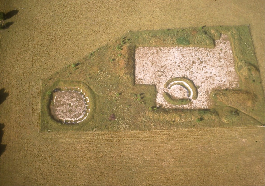
Wyke Down 2
Located 40m north-west of Wyke Down 1, Wyke Down 2 ‘henge’ was first identified as an indistinct crop mark from the air in 1995 by Marin Green, confirmed by geophysical survey and subsequently excavated in 1996. Removal of the overlying ground revealed two separate ditch segments, one semi-circular, the other banana-shaped in plan. These combined to form a roughly circular enclosure 12m in diameter, with an entrance at the southern end, facing towards Wyke Down 1. A series of oval pits, up to 1.75m in depth, survived in the base of the enclosure ditch, indicating the ditch was initially dug as a series of interconnecting pits. 10 were identified in the fully excavated western ditch segment, and at least one was identified in the partially excavated eastern ditch segment.
The pits/ditches were initially filled with a chalk rubble, interspersed with organic lenses; these seal a number of artefacts deposited on the base of the pits, including a carved chalk ball, animal bones and small fragments of Peterborough Ware. However, the southern terminal of the western ditch segment was notably different, with a rich organic basal deposit, incorporating an almost complete Grooved Ware vessel. The secondary silts above the primary chalk rubble contained sherds of Grooved Ware and Beaker ceramics, and in one ditch section, a midden deposit containing large quantities of pottery and fired clay, animal bone and worked flint, including two fine oblique arrowheads. Later activity was also recorded in the southern terminal of the western ditch segment, where a pit containing sherds of Grooved Ware had been cut into the silted ditch, clearly marking the location of the primary deposit of the nearly whole Grooved Ware vessel.
Structures and Pits
The area immediately to the west of Wyke Down 2 revealed a concentration of pits and postholes, including two small structures or buildings. Building 1 comprised an internal, roughly central, square setting of 4 post holes, an arc of small post holes to the west interpreted as the remains of a circular outer wall, an entrance to the south, and a central hearth or oven. These traces were interpreted as the remains of a circular building approximately 8m in diameter. Excavation of the post holes recovered large fragments of Grooved Ware, including pieces with concentric circular designs, a piece of scallop shell, and fragments of a chalk-based render with an outer lime-wash finish concentrated around the central four post holes. Further fragments of much coarser daub were recovered from the outer wall-line, suggesting that the building had a smaller square internal room, walled with fine and decorated chalk render, which was surrounded by the circular outer wall, made of coarser daub material. Many of the features within Building 1 contained large quantities of charcoal, suggesting it may have burnt down.
7m to the west of building 1, a second building (building 2) was identified. This had a similar ground plan to building 1, with an internal square four-post setting, a short arc of 3 post holes surviving at the east suggesting a structure diameter of c.7m, and 3 post holes that may have formed an entrance at the southeast. Artefacts from the post holes were very similar to building 1, including scallop shell and pieces of Grooved Ware, again with concentric circular designs. It is especially notable that in both building 1 and 2, the western post hole in the square setting contained scallop shell, and the southern post hole contained grooved ware sherds with concentric circular designs.
A concentration of pits and post holes were identified to the north and west of buildings 1 and 2, many of which contained specially selected and placed deposits of material. Both buildings had pits closely associated with them, which contained further sherds of Grooved Ware, daub, animal bone, and a carved chalk disk. To the southeast of building one, pit F.6 contained a dog skull and a partly polished flint ‘ball’, and was associated with a line of post holes. Closer to Wyke Down 2, a pair of pits (F1 and F2) contained a rich assemblage of Grooved Ware, and 2 oblique arrowheads. These were flanked by a pair of post holes, and possibly represent the remains of another building, or other structural element of the site. A number of other pits also contained clearly intentional and formal deposits, including a pit closest to Wyke Down 2, which contained a neonate pig skeleton, another pit containing fragments of red deer, pig and cow skulls, and a third containing a placed deposit containing red deer antler, Grooved Ware and lithics, including two arrowheads.
Dating Wyke Down 2 Buildings and Pits
The existing radiocarbon dates from the enclosure and buildings at Wyke Down 2 indicate activity taking place in the early 3rd millennia, and may suggest some form of sequence fro these three elements of the site. Our new dating work on this site will select suitable samples to produce a high precision chronology of the enclosure, the buildings, and the surrounding pits, which have yet to be directly dated. This will allow us to examine the temporal relationship between the different elements of this site, and the temporal relationship between this site, and those in the surrounding are, such as the neighboring Wyke Down 1 pit ‘henge’, or the similar depositional practices identified in the Grooved Ware pits in Fir Tree Field.
Furthermore, the buildings at Wyke Down are unusual within the British and Irish context, with only a handful of other examples of late 4th and early 3rd millennium structures known from sites such as Durrington Walls (Wiltshire), Trelystan (Powys) or Balgatheran (Co. Louth). More detailed dating will provide new insight into the spatio-temporal patterning of structures of this period, and their potential relationships with other forms of structure from this date, including the stone built structures on Orkney, and larger timber circles with square four post settings, which seem to share the same construction of the houses at Wyke down and elsewhere (e.g. Conybury ‘henge’).
Further reading/resources
Read this account, written by Martin Green, about the discovery and excavation Wyke Down 1 and 2
Barrett, J. C., Bradley, R. and Green, M. (2009) Landscape, monuments and society: the prehistory of Cranborne Chase. Cambridge: Cambridge University Press.
Barrett, J. (ed.) (1991) Papers on the prehistoric archaeology of Cranborne Chase. Oxford: Oxbow Books (Oxbow monograph, 11).
Fir Tree Field
Fir Tree Field is located on the western slopes of the upper Allen Valley, c.700m Southwest of Wyke Down, and c1.5km to the west of Monkton-up-Wimborne. Excavation in this area has revealed two areas of interest; the first is a group of 16 pits referred to by the excavators as ‘The Grooved-Ware associated site’, and the second, c.150m to the east of the first site, is ‘Fir Tree Field Shaft’, a large natural shaft containing artefactual material spanning millennia, and a number of pits in the surrounding area.
The Grooved-Ware site
Excavations at this site originally began to investigate a Bronze Age Enclosure, however, when the area was stripped, a total of 16 pits were also identified, split into a northern cluster (seven pits), a southern cluster (eight pits) and a single outlier, sitting 15m southeast of the northern cluster. The pits were rich in material culture, including stone tools, Grooved Ware and Peterborough Ware ceramics and animal bones, and a number had formal structured deposits at the base. These included a boar tusk, a flint scraper and a type VII polished axe from North Wales in pit 7, a whole cow skull placed on a red deer antler in pit 11A, a deposit of six red deer antlers in the base of pit 32, and a boar mandible and a polished stone axe in pit 29.
The excavators also noted that the pits took one of four forms-steep sided and flat based (A), shallow scoop (B), shallow sided and flat based (C), asymmetrical sides, shallowly shelving (D)-and the distribution of certain artefacts corresponded to different pit shapes. For example, all arrowheads and polished flint implements were recovered from type A pits, whilst all the boars tusks were recovered from type A and B pits. There were also patterns in which materials were found together; for example, lithics knapped from fresh flint from the chalk were recovered with pig mandibles, cow skulls, red deer antler picks, stone axes, arrowheads and decorated sherds of grooved ware pottery, but lithics knapped using flint from gravels were associated with animal vertebrae and long bone fragments, and undecorated sherds of Grooved Ware. These patterns support the interpretation that these depositions were structured by deliberate and selective actions.
Dating the Fir Tree Field Grooved-Ware site
Two existing radiocarbon dates, one from the norther cluster and one from the southern cluster, indicate activity in the early 3rd millennium, however, the ‘outlier’ pit 29 has not been dated, making it a priority. Further dating of materials from other pits within the northern and southern clusters will build a more detailed chronological sequence for the site, allowing an examination of the temporal relationships between pits in each group, and between the groups, as well as provide new dates for people undertaking certain practices and making, using and depositing specific types of material culture in this landscape, such as Grooved Ware ceramics or polished stone axes.
Fir Tree Field shaft and associated Grooved Ware and Beaker pits
Excavated between 1992 and 1996 by Martin Green, the site of Fir Tree Field Shaft is located c.150m to the east of the ‘Grooved-Ware associated site’. The site consists of the shaft, a natural swallet or swallow-hole created by the collapse of an underground cavern, a number of pits 15-30m to the west of the shaft, and a posthole defined roundhouse/structure directly to the north of the shaft. The shaft was excavated to a depth of 13.2m (although augering indicated the bottom was a further 12m below this level), which recovered a range of material culture dating from the 5th millennium BC (Late Mesolithic) to the 2nd millennium BC (Chalcolithic/Early Bronze Age), including lithics, animal bones and ceramics, specifically Early Neolithic bowl, Peterborough Ware and Beaker. The penultimate layer in the shaft sequence was a layer of packed chalk rubble, interpreted as a possible symbolic sealing or capping of the shaft.
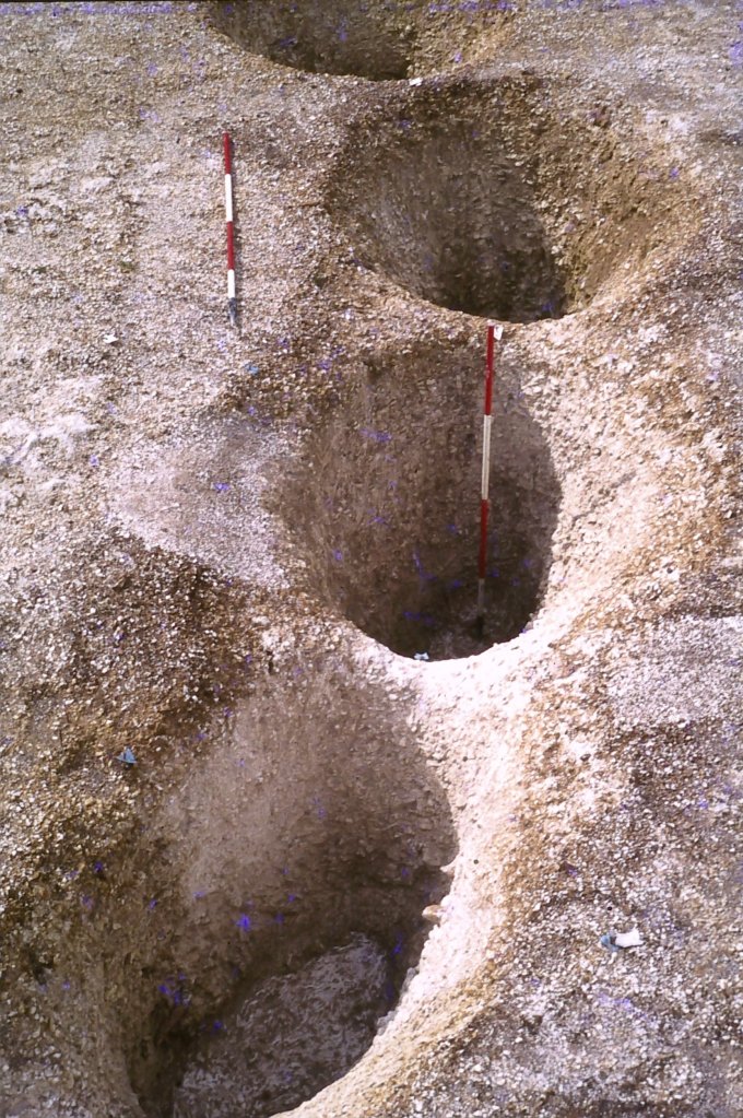
A total of six pits were identified to the west of the shaft; three were grouped together under 14m from the shaft (F.2, F.3 and F.4), with another two (F.5 and F.6) 8-10m to the north of this group, and a single pit (F.8) 20m south-southwest of this group. Based on their contents, these pits can be split into two general groups. Pits F6 and F8, which were smaller and shallower, both produced Grooved Ware ceramics, and also contained formal structured deposits on their base. F6. contained a deposit of animal bones and lithics, including the mandible of a cow, and a unique double-splayed axe. F8 contained a naturally perforated flint nodule, red deer antler tine and cow bones, in an arrangement that looked like a tusked animal skull, with the nodule perforations acting as like eye sockets.
Pits F.2, F3, F4 and F5 were larger than F.6 and F.8, had a distinctive sequence of deposition, and contained different material culture. In the F.2, F.3 and F.4 group, all three had basal deposits containing over 50% of the total artefacts from each pit, including lithics, ceramics, bone pins and animal bones, which were then sealed by loose chalky rubble. The layers above this rubble also contained artefactual material, but not in the same frequencies as the basal deposits. Interestingly, in both F.2 and F.3 a lens of sediment within the chalky rubble contained a partial but articulated young animal (a piglet in F.2 and a lamb or kid on F.3). Pit F.5 had a similar sequence of filling, however, it was not as rich in artefacts, and the basal fill only produced 17% of the total lithics and 7% of the total pottery from the feature. All four pits contained beaker ceramics, but also contained small pieces of earlier Peterborough Ware ceramics as well. In pit F.3, a small pit/post hole cut into the base before it was filled contained a large sherd of fine Wessex/Middle Rhine Beaker placed vertically, rim down, with the other end protruding above the floor of the main pit. More sherds of the same vessel were recovered from pit F.2, in both the upper and lower deposits, echoing the connection and similarity in practice that is shown by the deposition of the partial articulated animals in both of these features. The proximity of these pits to the Fir Tree Field Shaft, and the presence of Beaker in both the pits, and the final fills of the shaft, have led the excavator to suggest that the digging of pits F.2, F3, F4 and F5 produced the chalk rubble used to seal or cap the shaft.
Finally, 3m to the north-east of the shaft and c. 22m to the east of the pits F.2, F.3 and F.4, a circular setting of seven post holes, approximately 5m in diameter, with a possible entrance to the south-east, has been interpreted as a round house. A single ceramic sherd was recovered from one of these post holes, however, it was not obviously decorated and it may have been either Beaker or middle bronze age.
Dating Fir Tree Field shaft and Grooved Ware and Beaker pits
All of the existing dates for this site are from the shaft, which indicate a sequence of activity running from the 5th to the 2nd millennium BC. Therefore, new dating will focus on the associated Grooved Ware and Beaker pits. These will allow an examination of the temporal relationship between the pits containing different forms of material culture (e.g. Beaker and Grooved Ware), and it will allow a chronological sequence for the pits and shaft to be modeled. Furthermore, it will also allow a chronological examination of the relationship between depositional practice at this site, and other nearby sites, such as Wyke Down 1 and 2, and Monkton-up-Wimborne (as well as at the larger regional and national scale).
Further reading/resources
French, C., Lewis, H., Allen, M. J., Green, M., Scaife, R., & Gardiner, J. (2007) Prehistoric landscape development and human impact in the upper Allen Valley, Cranborne Chase, Dorset. Cambridge: MacDonald Institute for Archaeological Research.
Green, M., & Allen, M. J. (1997). An early prehistoric shaft on Cranborne Chase. Oxford Journal of Archaeology, 16(2), 121-132.
Griffiths, S. (2014). Points in Time: The Mesolithic–Neolithic Transition and the Chronology of Late Rod Microliths in Britain. Oxford Journal of Archaeology, 33(3), 221-243.
